
Shield-Carissa at a Glance
The Shield-Carissa property is located in the South Pass Mining District, a parallel orogenic shear zone district located approximately 18 kilometers west of the Lewiston Project. This property’s early exploration work suggests the apex of another strongly mineralized shear zone and is less than 1 kilometer from the historic Carissa Mine that produced over 180,000 ounces of gold historically.
- 3,847 acres (1,557 hectares) of active BLM lode mining claims, which include two historic mines – the B&H and Shields mines
- Relevant Gold rock chip samples up to 4.8 g/t Au
- > 3 km of East-Northeast anastomosing mineralized shear zone, parallel to the historic Carissa Mine trend
- Production at the adjacent Carissa Mine is estimated at 200,000 oz Au
- Gold mineralization hosted in quartz-arsenopyrite veins and arsenopyrite replacement zones at shear contact with Miner’s Delight wallrock
- Significant chlorite-silica-sulfide-epidote alteration
- Strong arsenic anomalies in both rock and soil

Geology and Mineralization
The Shield-Carissa property lies at the southwest margin of the South Pass/Atlantic City mining district, largely bounded to the north by the Atlantic Fault. In the overall geological and structural framework of the South Pass granite-greenstone terrane, the property occurs in the zone where major D2 wedge-shaped shear zones juxtapose mafic volcanic rocks of the lower Miners Delight Formation against typical Miners Delight metagreywacke.
2023 Exploration at Shield-Carissa
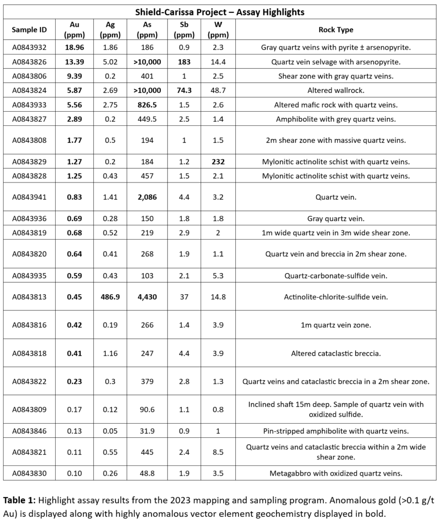
Previous (2019) reconnaissance work by the Company along the shear structures that host the historic B & H and Carrie Shields mines identified alteration and quartz veining typical of Abitibi-type orogenic-style gold systems. Grab sampling along the shears included highlight samples reporting 6.5 g/t Au. Several samples reporting high gold grades (>5 g/t Au), with the best two returning 18.9 g/t Au and 486g/t Ag (Table 1), have emerged from the Company’s more detailed 2023 work program that focused on the corridor between and along strike of these two historic mines. 2023 geological mapping and sampling identified five new mineralized shear zones, two of which appear to connect these historic mines (Figure 1). In addition to the 5 new shear zones, the 2023 mapping program identified multiple wedges of Abitibi-style mafic greenstone rocks including amphibolite and mafic metavolcanics where historical mapping indicated only metagraywacke rocks. These greenstone wedges are bounded by secondary shear structures and are hydrothermally altered to chlorite-actinolite-carbonate ± quartzoxidized sulfide schists cut by mineralized quartz veins reporting highlighted results of 5.56 g/t Au.
The 2023 work program defined three new target zones along the 2.7 km Shield-Carissa trend: 1) Palmetto, 2) Gold Nugget, and 3) Hornet (Figure 1). Each zone is characterized by high-grade gold hosted in shear zones cutting favorable greenstone host rocks and are further described below.
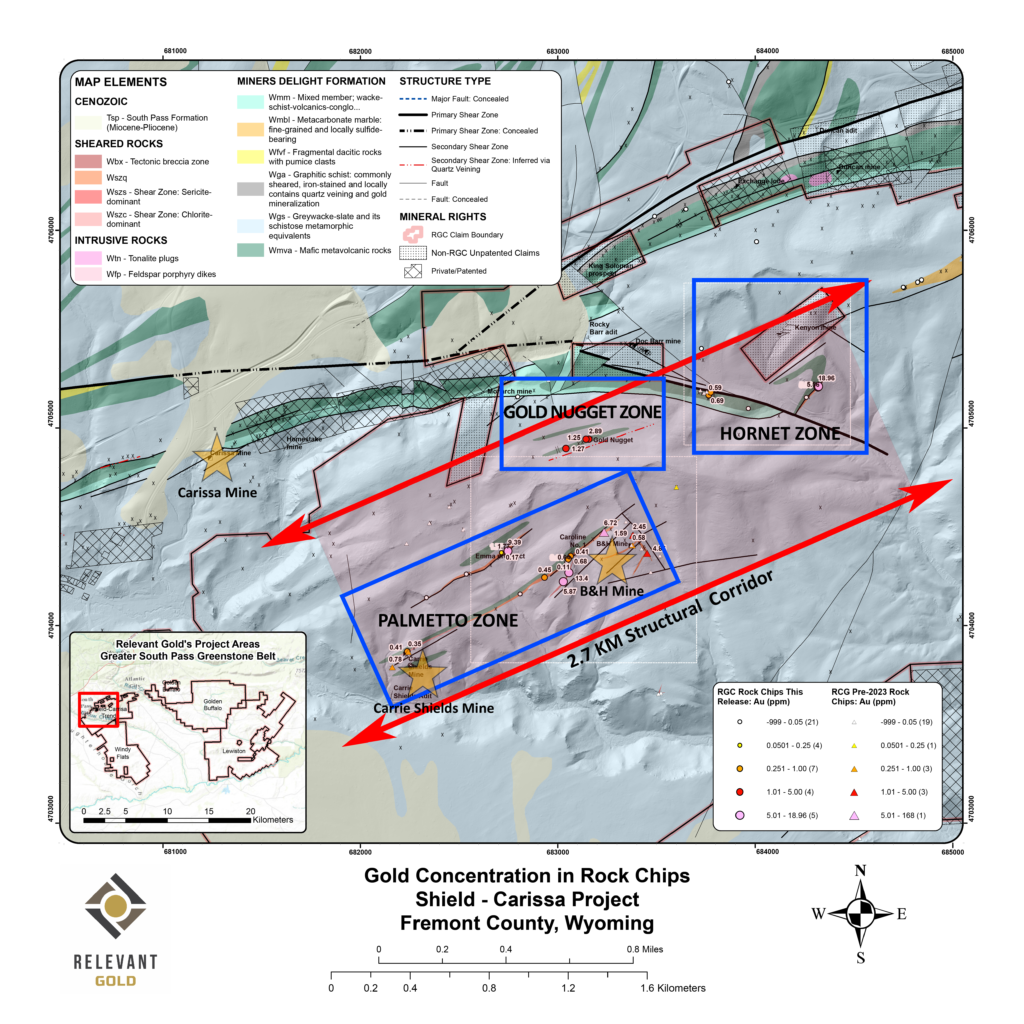
Figure 1: plan map highlighting 2023 rock chip sampling results and newly expanded target zones.
Palmetto Zone
The Palmetto zone lies at the southwestern end of the trend and incorporates at least three anastomosing shear zones that lie between, and host, the historical Carrie Shields and B & H mines. The shears are developed along the contacts between mafic rocks and Miner’s Delight metagreywacke and show multiple generations of quartz veining. The highest gold grades occur in gray quartz veinlets
carrying pyrite and arsenopyrite. Depending on host lithology, alteration selvages are dominated by chlorite-amphibole-carbonate or quartz-sericite-pyrite- both with minor tourmaline. The alteration selvages are commonly gossanous and is highlighted by samples returning 9.39 g/t Au and 13.4 g/t Au, locally with significant silver mineralization highlighted by a sample returning 486.9 g/t Ag. The surrounding limonite-stained, fractured country rock commonly hosts lower-grade gold mineralization.
The central shear appears to be the most continuous - traceable through outcrops for over 1 km from the Carrie Shields mine to northwest of the B&H mine. 2023 sampling along this shear is highlighted by samples returning 13.4 g/t Au, which corroborates earlier samples taken on this shear 150 meters to the NW of the B&H that returned highlighted samples of 6.72 g/t Au. The B&H mine shear runs about 150m to the southeast of the central shear and is traceable for approximately 600 metres. Prior sampling along the interpreted surface projection of the B&H shear found gold mineralization highlighted by samples
returning 4.85 g/t Au in outcrops and waste piles, with 2023 sampling ranging from below the detection limit to 5.87 g/t Au. The third shear runs parallel to, and about 250m northwest of, the central shear
and is the least well defined. Sampling along it reports highlighted values of 9.32 g/t Au.
Gold Nugget Zone
This mineralized structure lies north of the Palmetto Zone and is intermittently exposed through cover. It is traceable through historic exploration diggings including a series of backfilled shafts and small
prospects. Dumps here show mylonitized, hydrothermally altered amphibolite and gray, quartzcarbonate veins which reported from below detection limit to 2.9 g/t Au.
Hornet Zone
This mineralized area lies more or less on strike with and to the northeast of the Palmetto Zone. It appears to be a splay off the regionally important Anderson Ridge Fault and includes at least two mineralized strands. Mineralization is similar to that seen elsewhere in the South Pass Greenstone Belt and has yielded the highest-grade sample collected to date from the entire Shield-Carissa project area
from a 1-2m wide shear zone developed along the limb of an anticline. Here, the contact between amphibolite and metagraywacke is cut by quartz veining with a broad alteration selvage from which
separate selected grab samples returned 18.96 g/t Au and 5.56 g/t Au, respectively.
Summary
The Shield-Carissa project fits the Abitibi gold model and continues to show strong correlation to the directly adjacent +180,000oz historic Carissa mine. Further exploration and definition of the wedges of
mafic rocks and mineralized shear structures throughout the property will be an important next step to refine drill targets. The 2.7km footprint of mineralized shear structures and alteration indicates a very large mineralizing system that has never been drilled. Additionally, this project continues to illustrate its connection to the Abitibi gold belt during the time of gold mineralization, further supporting district-scale orogenic potential at Shield-Carissa and throughout the rest of the Company’s Wyoming portfolio.

Historic Mining at the Carissa Mine
Historic mining was developed on small scales, at narrow widths, and largely confined to oxidized ores above the water table (<80 feet). Available data suggest that much of the strike length of a given shear-hosted vein system is anomalous in gold with localized steeply plunging high-grade ore shoots systematically occurring parallel to the trend and plunge of stretching lineations.
The deepest and best-documented gold mine is the Carissa Mine outside of South Pass city. The mine was developed down to a depth of 400 feet along five main levels along a shear zone with abundant gold-bearing quartz-arsenopyrite-pyrrhotite veins. A vertical long-section (Macfarlane report, 1995) of the Carissa Mine, parallel to the strike of the main ore zone is presented to the left.

Shield-Carissa News
