
Bradley Peak at a Glance
The 100% owned Bradley Peak property is located in the Seminoe Mountains in central Wyoming and is comprised of multiple orogenic shear-zone hosted mineralization styles including VMS style mineralization with increased copper grades associated with the gold mineralization.
- 10,800 acres (4,391 hectares) of active BLM mining claims with 100% ownership by Relevant Gold Corp
- 50 km of new shear zones identified with classic orogenic gold and volcanogenic massive sulfide style mineralization observed across the greenstone belt district.
- 6 high-grade targets identified in 3 district-scale target zones: Kortes, Apex, and Hidden Treasure
- Relevant Gold 2024 rock chip samples highlighted by 46.8 g/t Au, 7.8% Cu, 2% Zn; Historic samples up to 89 g/t Au + 5.8% Cu;
- 2023 airborne geophysics depicts a massive 100+ km2 fold hinge anomaly
- >2.5 km trend of mineralized structure at Apex
- Host Lithologies: Rheologic contrasts, amphibolites and greenstones, and carbonate facies iron formation
- Minerology: Gold-Arsenopyrite-Chalcopyrite-Pyrite-Pyrrhotite
- Vector Elements: Au-Ag-Sb-Hg-Bi-Cu-W
- Structure: Major shear zones, brittle-ductile transition, and complex re-folded folds

Above: Plan view map of airborne geophysical anomalies draped over LiDAR at Relevant Gold’s Bradley Peak Gold Camp. Exploration targets identified by the Company are: 1) Apex, 2) Kortes, 3) Deserted Treasure, 4) Lost Mine, 5) Olmeh, and 6) East Limb. Below: A comparison of the exploration targets identified by Relevant Gold at the Bradley Peak Gold Camp. Highlighted grades include assays from all previous RGC sampling.

Regional Magnetics Survey
In 2023 the Wyoming Geological Survey (WSGS) and U.S. Geological Survey (USGS) flew an airborne magnetics geophysical survey covering the Company’s entire 16,000-hectare portfolio of projects. The survey revealed structural and geological details far surpassing existing mapping. Importantly, some of the most prominent anomalies highlighted by the survey are major structures at South Pass and Bradley Peak gold camps. The survey shows patterns very similar to those of Canada’s Abitibi Gold Province and provides strong support for the Company’s exploration thesis that Wyoming has Abitibi-style geology and gold potential.
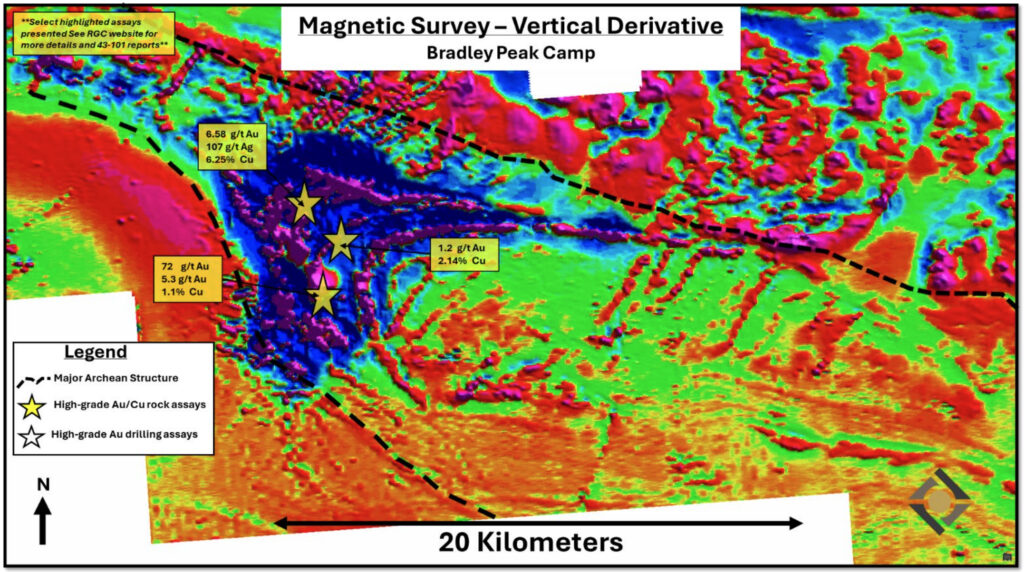
Figure: Regional airborne magnetic survey vertical derivative map of Bradley Peak Gold Camp with Relevant Gold’s high-grade gold targets, select assays, and major structures highlighted.
Apex Target Zone
The Apex Zone encompasses a set of closely spaced, sub-parallel shear zones traceable for more than 2.5 km through amphibolite facies metabasalt and metagabbro intruded by porphyries and mafic dikes. The zone runs through the historic Apex Mine and Sunday Morning prospect workings, which historically reported assays of up to 2.1 g/t Au (see News Release dated 11/07/2023). 2024 work found high-grade gold, copper and zinc mineralization throughout the zone. The highest-grade sample (46.8 g/t Au) was taken 500 m along strike and 200 m vertically below the historic mine workings, from a 3 m wide mineralized quartz vein within a >10 m wide shear zone outcrop (Figure 3). Gold mineralization appears to have a positive correlation to bismuth and arsenic in the reported rock geochemistry, which supports Abitibi-style orogenic mineralization.

Above: Map illustrating high-grade gold and copper assays from the Company’s sampling programs at the >2.5km long Apex Target zone within the central Bradley Peak Gold Camp. Gold values range from >0.015 g/t to the highest-grade assay of 46.8 g/t Au. Copper values range from below detection limit (“BDL”) to 7.8%. Below: Photo showing the lower Apex mineralized vein exposure and the five panel samples that were taken across the sections of the 3 m outcrop exposure; the photo is looking to the southwest.

Bradley Peak Gold Camp: Key Characteristics
CRITERIA |
DESCRIPTION |
|
| STRUCTURAL SETTING |
• Major shear zones • Brittle-ductile transition • Complex re-folded folds • Rheologic contrasts |

|
| HOST ROCK |
• Amphibolites and greenstones • Carbonate facies Iron Formation • Mafic and felsic intrusives • Komatiites |
|
| ALTERATION |
• Chlorite, Carbonate, Sericite, Epidote, Sulfidation, and Silica |
|
| GEOCHEMISTRY |
• Au, Ag, As, Bi, Cu, Sb, Pb & Zn
|
|
| MINERALIZATION | • Gold, arsenopyrite, chalcopyrite, pyrite, pyrrhotite |
|
| LAND POSITION | • 100% RGC ownership of 281 contiguous unpatented active BLM claims
• Rural sub-mountainous terrane • ~50 miles from well-established town and infrastructure |
|
| SCALABLE OPPORTUNITY | • Multiple district-scale targets • RGC controls 98% of the entire greenstone belt camp |
|
| PERMITTING | • Streamlined State and Federal permitting pathway |
|
Bradley Peak News
