
Lewiston at a Glance
The Lewiston Project is located south of the Wind River Mountain Range in west-central Wyoming. The project site is located approximately 65 kilometers southeast of Lander, Wyoming (Figure 1.1) in Fremont County and is composed of both private land and public land managed by the Bureau of Land Management (BLM).
- 13,887 acres (5,620 hectares) of active BLM mining claims, including 58 acres (23 hectares) of patented claims at Hidden Hand.
- >10 km mineralized shear zone trend.
- Relevant Gold’s Lewiston project claims include the historic Hidden Hand, Burr, Goodhope, and Lone Pine mines.
- Historic reported samples include 1,690 oz/ton Au; Relevant Gold rock chip samples up to 62 g/t Au + 8.1% Cu.
- Arsenic (As), Antimony (Sb), Tungsten (W) and Copper (Cu) enriched shear zones that historically have reported significant high-grade bonanza style gold within the shear structures and associated veining.
- Relevant Gold has two permitted drill targets at Lewiston with a third permit pending.
- Click here to view the NI43-101 technical report for this project.
Regional Magnetics Survey
In 2023 the Wyoming Geological Survey (WSGS) and U.S. Geological Survey (USGS) flew an airborne magnetics geophysical survey covering the Company’s entire 16,000-hectare portfolio of projects. The survey revealed structural and geological details far surpassing existing mapping. Importantly, some of the most prominent anomalies highlighted by the survey are major structures at South Pass and Bradley Peak gold camps. The survey shows patterns very similar to those of Canada’s Abitibi Gold Province and provides strong support for the Company’s exploration thesis that Wyoming has Abitibi-style geology and gold potential.

Figure: Regional airborne magnetic survey vertical derivative map of South Pass Gold Camp with Relevant Gold’s high-grade gold targets, select assays, and major structures highlighted.
Exploration and Development Timeline
2024 Exploration at Lewiston

Above: Geologic map of Relevant Gold’s Lewiston property depicting the locations of the 2023 drill program at Heavy Hand and the 2024 drill program at the Burr target, as well as the >10km structural corridor that connects these targets.
The 2024 drilling campaign at the Burr Targetin Lewiston saw all six drill holes intersected appreciable gold mineralization. The program included six HQ diamond core drill holes totaling 1,026 metres (m), and each hole intersected shear-hosted gold mineralization below and lateral to historical mine workings. The results confirm a large orogenic gold footprint with strong discovery potential for follow-up drilling at Lewiston.
Assay Highlights*:
- 2.2 g/t Au over 1.5 m within a broad zone of mineralization averaging 1.4 g/t Au over 2.4 m,
- 1.3 g/t Au over 1.85 m within a broad zone of mineralization averaging 0.33 g/t Au over 9.2 m,
- 1.8 g/t Au over 0.8 m,
- 1.2 g/t Au over 0.81 m within a widespread shear-hosted gold zone highlighted by 23 m averaging 0.13 g/t Au.
*All reported intercepts are core length.
See the full table of results for more information.

Above: (Left) Plan view geologic map with drill hole traces and gold results and the cross-section line A – A’. (Right) Cross-section A – A’ with geology and drill traces with associated gold results for holes 24HH-1, 24HH-4 and 24HH-5 and approximate shaft locations for the Hidden Hand and Morris mines.
For a full technical summary, view the Company’s Lewiston 43- 101 technical report.
2023 Exploration at Lewiston
During the 2023 field season, Relevant Gold drilled 11 holes totaling 1,560 m of diamond core at the Heavy Hand target. Drilling intersected shear-hosted gold mineralization in 10 of 11 drill holes, cutting multiple near-vertical shears across a 500 m wide corridor, 600 m along strike, and to vertical depths of 225 m, illustrating a sizeable oxide gold footprint at the apex of a prominent orogenic gold system. Mineralized shear structures are highlighted by 10 m (core length) averaging 0.35 g/t Au in hole 23-LD011 and 6 m (core length) averaging 0.29 g/t Au in Hole 23-LD010 including 1 m (core length) of 0.96 g/t Au. Narrow higher-grade shears are highlighted by 0.5 m (core length) of 1.9 g/t Au. and 0.7m (core length) at 1.72 g/t Au.
“We cut gold in almost all of the first holes ever drilled into a 500 m X 1000 m target, demonstrating that Lewiston hosts a large, fertile orogenic gold system that is begging to be drilled deeper. So far, Heavy Hand checks all the early boxes necessary to quickly evolve into a major gold discovery in Wyoming,” said Rob Bergmann, Relevant Gold CEO. “These results give us a second district-scale, Abitibi-like discovery opportunity and we have another 10 targets in the pipeline ready to advance across our portfolio.”
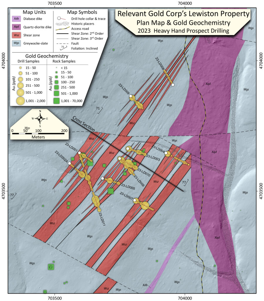
Figure 1. Plan view map of the Heavy Hand target with drill hole traces in red, gold assays in yellow, and surface
rock chip gold assays in green (100 ppb = 0.1 g/t) along with geology projected to surface. The cross-section line is
also illustrated as a NW-SE slice in Figure 2.
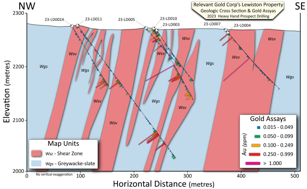
Figure 2. Cross section of drill holes looking NE illustrate gold assays and geology.
The Lewiston project comprises 10 km of orogenic shearing with gold associated throughout. Numerous shear zones have been mapped in detail throughout the district ranging from <1 m to >15 m wide at surface. Mineralization is seen as gold-bearing quartz veins with arsenopyrite + pyrite + chlorite +/- biotite +/- scheelite within the shear zone. The shear zones are flanked by brittle stockworks and alteration consisting of silicification and chloritization. Heavy Hand is a 500 m x 1 km+ greenfield target identified as multiple sub-parallel and near vertical orogenic shear zones with high-grade gold (Relevant Gold surface rock chip samples highlights include 62.4 g/t Au), distinct hydrothermal alteration, and associated orogenic geochemistry (As, W, Bi, Te, Sb, Ag). Heavy Hand is one of two major targets in the northern Lewiston project identified to date through systematic exploration.
For a full technical summary, view the Company’s Lewiston 43- 101 technical report.
Early Exploration at Lewiston
Field reconnaissance, mapping, and sampling of the Lewiston Project were performed by Big Rock Exploration, LLC, on behalf of Relevant Gold Corp. between 2019 and 2021.
Multiple shear zone orientations and brecciated fold hinges were identified in the Lewiston Project and demonstrated spatial associations with alteration and mineralization. Mapping within the project area outlined a regional scale anastomosing shear system with at least two distinct shear orientations:
- A dominant system of NE-striking shear zones cross-cut the entire project area, demonstrating chlorite alteration
- A later or coeval, widespread set of E-W striking shear zones and altered fracture zones hosting silica-epidote-sulfide alteration
2022 rock chip samples were collected within the project area. Sample assay values range from detection limit to 62 g/t Au, including 13 samples >1 g/t Au (6.4% of sample suite) and 29 samples >0.25 g/t Au (14.3% of sample suite)

Geology and Mineralization
There are two historic mining districts in the region: the Lewiston District and the Atlantic City/South Pass district. Both mining districts are in a belt of Archean rocks and saw periodic activity from the 1860s to the 1940s. Since that time, the districts have seen only limited exploration and artisanal mining. In the Atlantic City/South Pass District, several gold mines were developed, including the most productive, the Carissa Mine. The Carissa Mine produced over 100,000 oz, with historic estimates range 50,000-180,000oz (Jamison, 1911; Hausel, 1991). The Lewiston District had smaller historic development but had reported very high gold grades.
The Lewiston Project lies within the South Pass Greenstone Belt (SPGB), an Archean (3,875 to 2,750 Ma) greenstone belt located on the southern flank of the Wind River Range in the Southern Wyoming Province. The geological characteristics of the SPGB are consistent with other world-class orogenic gold systems.
The Lewiston district consists of a large package of metagreywacke from the Miners Delight Formation. Like the western Atlantic City District (Section 6), there are mafic-ultramafic rocks intermixed with the sedimentary rocks. Adjacent to the Miners Delight Formation on the east side is the Roundtop Mountain Greenstone sequence, but it is poorly exposed. The district is bound to the east by the extensive Lewis Lake Batholith that consists of calc-alkaline granitoids and gneisses. There are localized Tertiary cover rocks in the project area consisting of sandstones, conglomerates, and gravels.
Historically, the gold mineralization occurs within shear zones with multigenerational quartz veining, with high-grade free gold associated with oxidized quartz veins. The Lewiston Project has at least two major fold orientations as well as two orientations of shearing. The primary shear corridor is oriented NE-SW with a strong lineation plunging to the NE along the shear fabric. This, along with an intersecting E-W shear zone, may create structural conduits for goldbearing fluids to travel along and mineralize the shear zone and surrounding wallrock near reactive horizons. Mineralization is seen as gold bearing quartz veins with Arsenopyrite + Pyrite + Chlorite +/- Sheelite within the shear zone. Outside the core of the shear zones, there is brittle stockwork silicification + chloritization.
Lewiston News
